On our way to Yellowstone National Park- First Stop is Page, AZ
- Deborah Kade
- May 3, 2024
- 5 min read

Taking a long road trip to Yellowstone and The Tetons. First stop is Page, Arizona. We are staying at the Marriott as the Tesla charger is located there. This will be our first long trip with the Tesla Model X.
The only snow from last week's snow storm in Flagstaff is on the mountains.


Leaving Flagstaff


Cameron Bridge
The Cameron Suspension Bridge crosses the Little Colorado River in Cameron, Arizona.

"The bridge formerly carried U.S. Route 89, but was replaced by a newer deck truss bridge in 1959. Built in 1911, it has an overall length of 680 feet (210 m) and a main span of 660 feet (200 m). The bridge was built by the Midland Bridge Company of Kansas City for the Office of Indian Affairs and the Indian Irrigation Service. W. H. Code of the Midland Bridge Company was the designer. The suspension design was chosen to address the steep-walled canyon at the crossing, which required a single span with no temporary falsework. When built, the Cameron bridge was the longest suspension span west of the Mississippi River."

"The bridge towers rest on the rim of the canyon, with concrete deadmen anchoring the suspension cables some way back from the towers. The deck is stiffened by a Pratt through-truss, with a 14-foot (4.3 m) wide roadway. The bridge was built to improve access to the Navajo Nation and the Hopi Indian reservation. Named for U.S. Senator Ralph H. Cameron, it was an important link for the construction of the Navajo Bridge on US 89 across the Colorado River in 1929. The town of Cameron grew up around the crossing, which in addition to opening up the Native American lands to the north, also provided a northern gateway to the South Rim of the Grand Canyon when the Navajo Bridge opened."

"The bridge was damaged by an overload of sheep in 1937, when it almost collapsed. The damage was repaired and the bridge served highway traffic until 1959. It was sold to the Four Corners Pipeline Company when the new bridge opened, and carries a natural gas pipeline. The Four Corners Pipeline was eventually acquired by Questar Pipeline and is now a part of theSouthern Trails Pipeline.
The Cameron Suspension Bridge is the oldest suspension bridge in Arizona, and one of only two of that type in the state.
The Cameron Suspension bridge was added to the National Register of Historic Places on June 5, 1986."

Driving through the Navajo Nation on U.S. Route 89.
Did you know??????
"More than 500 mines across the Navajo Nation once supplied uranium that helped power the U.S. Department of Defense's nuclear arms development, including the Manhattan Project during World War II, but not a single one has been completely cleaned up in the decades since, according to the Environmental Protection Agency."
"In 1944, uranium mining under the U.S military's Manhattan Project began on Navajo Nation lands and on Lakota Nation lands. On August 1, 1946, the responsibility for atomic science and technology was transferred from the military to the United States Atomic Energy Commission."
"Who benefited more from the mining that was done on the Navajo reservation?
Not only did the mine provide hundreds of high-paying jobs to the mostly Native American workforce – a workforce in dire need of quality employment opportunities – it provided important royalty and tax revenue to the Navajo Nation itself."
"What has contaminated the groundwater on the Navajo Nation?
Cold-war era uranium mining on Navajo land has poisoned wells, uncontrolled landfills have contaminated groundwater supplies, and pesticides leach into irrigation reserves."
"How did the US poison the Navajo Nation?
Many Navajo people have died of kidney failure and cancer, conditions linked to uranium contamination. New research from the CDC shows uranium in babies born now. Mining companies blasted 4 million tons of uranium out of Navajo land between 1944 and 1986."
"Why does Navajo Nation not have water?
The rural terrain and sparse population in many areas pose unique challenges for traditional piped water solutions. IHS estimates that it will cost over $700M to provide access to safe drinking water and basic sanitation to all Navajo homes."
"What was the toxic spill on the Navajo Nation?
On August 5, 2015, 3 million gallons of acid mine drainage was accidentally released from the Gold King Mine spill, eventually reaching the San Juan River - the spiritual and physical lifeblood of the Navajo Nation."
"How many Navajos don't have running water?
Up to 40 percent of Navajo homes in some areas don't have clean, drinkable running water. In the past, the Diné would take their animals to places where grass and water were found."
"How do Navajos get water?
Without piped water, residents haul water either from regulated watering points or from unregulated water sources, such as livestock (windmill) wells and springs. The number of unregulated water sources on the Navajo Nation is estimated to be in the low thousands."


Orange globemallow growing along the roadside as we approached Page.
"Globemallow is a flowering herb. The leaves have been used to make medicine. Globemallow might reduce inflammation and improve immune function, but its effects in humans are unclear."
"Sphaeralcea ambigua, commonly known as Desert Globemallow, is a member of the genus Sphaeralcea in the mallow family (Malvaceae). It is a perennial shrub native to parts of California, Nevada, Utah, and Arizona in the U.S.; and Sonora and Baja California in Northwest Mexico"
"Tiny leaf hairs on the globe mallow are an eye irritant, which is probably why they are also called sore-eye poppies or pink-eye poppies. These hairs are thought to discourage herbivores from eating the plant."
Although desert globemallow is edible, it unfortunately does not have a taste to match the brilliance of its flowers. However, it is a food source for the desert tortoise and provides browse for bighorn sheep and livestock. Globe mallow is cold hardy to about 20 degrees F. Although most globe mallow plants produce orange flowers, they are available in other colors including pink, purple, white, red and shades in between.

Globe mallow attracts hummingbirds as well as butterflies.
"Historically, globe mallow was used by Native Americans for medicinal purposes such as treating diarrhea, sore throats, eye diseases as well as skin disorders. Their roots were used for upset stomachs and poultices were made for treating swollen joints and broken bones."
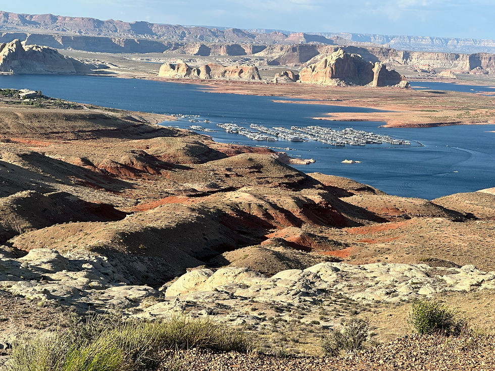
Wahweap Overlook
For a panoramic view of Lake Powell, Wahweap Overlook is hard to beat. Located near the Wahweap Marina in Page, Arizona, this viewpoint offers a sweeping vista of the lake and its surrounding landscape. Lake Powell is part of the Glen Canyon National recreation area.


Michael received a message on his watch warning that we had reached 90 decibels and if we stayed for 30 minutes longer, we could incur healing loss.
WARNING: WARNING TURN THE VOLUME DOWN!!!!!!!!! YES, THAT IS THE WIND HOWLING!!!!!!!!!
I took this picture of my shadow. Big body, long legs but still a tiny head.

Navajo Mountain off in the distance

Navajos consider Navajo Mountain as a sacred area, and ascending it is forbidden. Navajo Mountain has a volcanic origin, though laymen would never think so by looking at it. Some of the only volcanic rock visible is on the mountaintop's north end.

Glen Canyon Dam
Glen Canyon Dam is a concrete arch gravity dam located on the Colorado River. The 710-foot-high (220 m) dam was built by the Bureau of Reclamation (USBR) from 1956 to 1966 and forms Lake Powell, one of the largest man-made reservoirs in the U.S. with a capacity of more than 25 million acre- feet (31 km3). The dam is named for Glen Canyon, a series of deep sandstone gorges now flooded by the reservoir; Lake Powell is named for John Wesley Powell, who in 1869 led the first expedition to traverse the Colorado River's Grand Canyon by boat.


The Marriott is located among the small cropping of trees in front and to the side of the golf course.


Comments