
Zermatt, Switzerland
- Deborah Kade
- Sep 19, 2018
- 5 min read

Updated: Oct 13, 2019
The plan for today was Bremgarten, a place I have never visited. Decided to change plans and wait to visit Bremgarten when Michael comes. So, after checking the weather for a few places, I decided on Zermatt.
Zermatt lies at the foot of the Matterhorn.

The town's touristic development is closely linked to what is most probably the world's most famous mountain. The vacation destination is a car-free zone, has preserved its original character and offers nearly unlimited possibilities as far as excursions are concerned.


Zermatt has a population of about 5,800 inhabitants and is classified as a town by the Swiss Federal Statistical Office. With tourists, the population more than doubles in the summer and the winter, though.
There is so much construction taking place in town. Many roofs being repaired.
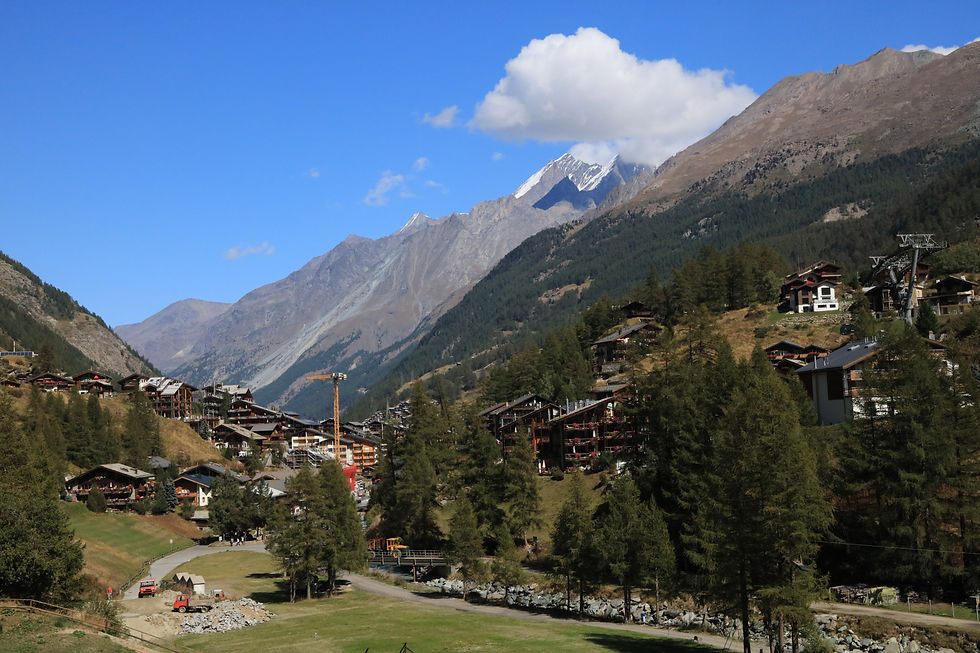


Zermatt lies at the upper end of Mattertal at an elevation of 1,620 m (5,310 ft), at the foot of Switzerland's highest peaks. It lies about 10 km (6.2 mi) from the over 10,800 ft (3,291.84 m) high Theodul Pass bordering Italy.
Zermatt is famed as a mountaineering and ski resort of the Swiss Alps. Until the mid-19th century, it was predominantly an agricultural community; the first and tragic ascent of the Matterhorn in 1865 was followed by a rush on the mountains surrounding the village, leading to the construction of many tourist facilities. Much of the local economy is based on tourism, with about half of the jobs in town in hotels or restaurants and just under half of all apartments are vacation apartments.
The name of Zermatt, as well as that of the Matterhorn itself, derives from the alpine meadows, or matten (in German), in the valley. The name appeared first as Zur Matte ("at the meadow") and became later Zermatt. It does not appear until 1495 on a map or 1546 in a text, but may have been employed long before.
Praborno or Prato Borno (prato also means meadow) are the older names of Zermatt; they appear in the ancient maps as early as the thirteenth century. The Romand-speaking people from the Aosta Valley and from the Romand-speaking part of canton Wallis (Vallais) used this name until about 1860 in the form of Praborne, or Praborgne. The reason of this change from Praborno to Zermatt is attributed to the gradual replacement of the Romance-speaking people by German-speaking colony.
The town of Zermatt lies at the southern end of the Matter Valley (German: Mattertal), which is one of the lateral branches of the grand Valley of the Rhône. Zermatt is almost completely surrounded by the high mountains of the Pennine Alps including Monte Rosa (specifically its tallest peak, named Dufourspitze), Switzerland's highest peak at 4,634 meters (15,203 ft) above sea level. It is followed by the Dom 4,545 m (14,911 ft), Liskamm 4,527 m (14,852 ft), Weisshorn 4,505 m (14,780 ft) and the Matterhorn 4,478 m (14,692 ft).
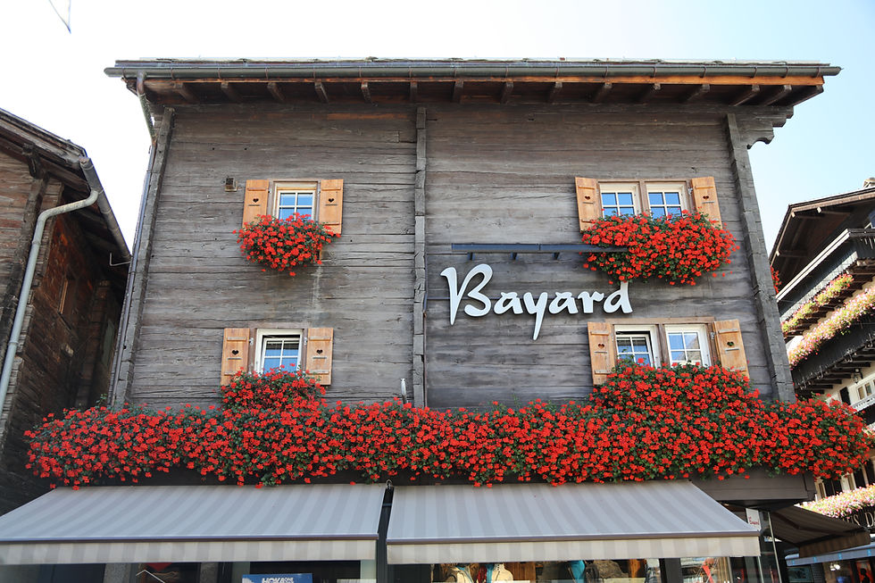
There are many shops, restaurants, hotels, vacation rentals and homes bunched together in a small area. The one thing they all have in common.......beautiful flowers. The flowers of choice are hanging geraniums and petunias.


A very unique church. I said a prayer for everyone whom are following my day to day travels but there were no candles to light.


Ornate altar

Painted on the ceiling.

Quite ornate

Many homes have stone roofs.

The main attraction in Zermatt- The Matterhorn! Clear sky except for over the Matterhorn and the surrounding mountains. It still is an impressive mountain.


The Matterhorn is a mountain to be respected. Here are ten things you may not know about the Matterhorn.
1. At 4,478 meters (14,692 feet), the Matterhorn is only Western Europe’s 12th-highest peak, but it is taller than Mt. Whitney, the highest summit in the Lower 48 of the U.S., by about 187 feet.
2. The Matterhorn straddles two countries, Switzerland and Italy, and has three common names. The German name Matterhorn derives from the words for "meadow" and "peak." The Italian name (Cervino) and French (Cervin) likely originated with the Latin word for forest, silva, though some believe it comes from the Italian and French words for “deer.”
3. The first ascent on July 14, 1865, from the Swiss side of the mountain, ended a race that lasted nearly a decade and came down to the wire, with rivals on the Italian side poised only 1,250 feet below the top when Edward Whymper and Michel Croz first reached the summit. In order to ensure his rivals knew they were beaten, Whymper rather unsportingly shouted at the Italian team from the top and hurled rocks to make a clatter. “The Italians turned and fled,” Whymper wrote in his famed book Scrambles Amongst the Alps.
4. The glorious victory was marred when, during the descent, four of the seven climbers in the summit party fell to their deaths. The remaining three, including Whymper, likely would have fallen as well if the rope linking the men had not broken.
5. The second route up the Matterhorn, the Lion Ridge from Italy, was completed just three days after the first, on July 17, 1865.
6. Since the first ascent, more than 500 people have died while climbing or descending the Matterhorn—an average of three to four per year.
7. About 3,000 people summit the Matterhorn annually. However, starting in 2015, by reducing the size of the hut at the base of the most popular route, the Hörnli Ridge, and eliminating camping outside the hut, Swiss officials hope to slash the number of climbers by as much as one-third and reduce crowding on the mountain. About 80 percent of Matterhorn climbers are either guides or clients.
8. Both a railway and a cable car to the summit of the Matterhorn have been proposed. The latter, a tramway from the Italian town of Breuil-Cervinia, was proposed in 1950 but scuttled after tens of thousands of people protested to the Italian government.
9. Emil Cardinaux’s striking poster of the Matterhorn, designed as a card in 1903 and printed as a tourism poster for Zermatt in 1908, is considered the first modern travel poster and a landmark of 20th-century design.
10. The mountain was closed to all climbing on July 14, 2015, out of respect for those who have died on the peak. July 14, 2015 was the 150th anniversary of the successful ascent.
I hiked up toward the mountain a short distance. I came upon fields of wild crocuses.


Notice the small butterfly in the middle crocus.

So many things to notice along the walk through town.


I decided to have a late lunch at the Alpen Rose. This is the restaurant Michael and I usually frequent when we are in Zermatt. The food is fresh and very delicious but the main reason we stop is for view of the Matterhorn while we eat. It is priceless!!!


This marmot sculpture is close to the church. I actually saw a real marmot next to the train tracks on the ride up from Visp to Zermatt. The marmot was standing up straight next to a hole. I wonder if it was the lookout for danger.

This view greeted me when I came back to Sunny Days. The moon is rising over the Mönch.

View from my room at Sunny Days.


This was a perfect day to enjoy the mountains of Switzerland!


Comments